Looking back at the sunrise over Denver after the climb out.

My second goal on this trip was to take the scenic ride up Mount Evans. I read about the ride in a map book I bought that lists the top motorcycle rides in North America. When I planned the trip, I scheduled an extra day in Colorado to allow me to make the ride.
I reached the town of Idaho Springs at a little after 7:00am and had breakfast at the local McDonalds. Idaho Springs is a small touristy town about 40 miles west of Denver. The town’s roots are in the Colorado Gold Rush and like Dahlonega back home they’ve leveraged that history along with skiing and river recreation to draw in tourists. The main strip boasts 20 or so little shops. I don’t want to sound too jaded, but it’s the same rejuvination formula I’ve seen played out in towns everywhere. Little restaurants, candle, fudge, and art shops cling to existence. Vacant shops dot the street marking those that lost the economic battle.
I was interested in Idaho Springs because the road up Mount Evans begins there. The road has the distinction of being the highest paved road in North America reaching a height of 14,130 feet. Even the road up Pike’s Peak does not climb as high. It’s worth noting here that aircraft generally require oxygen above 10,000 feet. After I finished my breakfast I rolled through town and found the road almost by accident.
The road to the top of Mount Evans is 28 miles long. It starts out very tame. It meanders along for 14 miles with turns and inclines no more severe than those in the Georgia Mountains. Of course, the highest Georgia Mountain is 4,600 feet (Brasstown Bald) and the Mount Evans road starts well above 7000 feet.
At the end of the first 14 mile section the road has climbed to 10,000 feet and there is a pristine mountain lake called Echo Lake, a souvenir stand (of course), and a ranger’s station. There’s a big sign here that says Motorcycle Riders should use Extreme Caution. This is where you should turn back if you have any doubts of your ability to navigate an 800 pound motorcycle along a narrow road with 90 degree turns on a steep (and I mean steep) upgrade with no guard rails or shoulders.
To understand how scary this road is you need to understand a few things about motorcycles and heavy motorcycles in particular. Motorcycles are incredibly stable at speed. Think about it; how many people fall over on bicycles once they are moving; not too many. The wheels act as gyros (when they are turning) and provide stability. This is why motorcycles can lean so far into turns and never fall over. This all falls apart however when bikes go slow. Like airplanes, motorcycles are clumsy at low speed. This is why most motorcycle accidents occur in parking lots.

You can’t go fast on the Mount Evans road; not for long anyways. I rarely took the bike out of first gear for the climb from 12,000 feet to 14,000 feet. My speed hovered around 15 miles per hour and I had to take some pretty nasty turns, but that’s not the worst part. The worst part is knowing you can’t stop and turn around. The road is too steep and too narrow. If I let the bike stop, and believe me the thought crossed my mind more than once, I would have been stuck. The bike is way too heavy to push around. I imagined myself paralyzed in the middle of the road.
Somewhere around 11,000 feet the trees disappear. It’s like climbing through a cold windswept desert that you could fall off of at any second and die a horrible death. Along the way I passed mountain goats and small ground hog like animals that I guessed to be prairie dogs.
I was not alone. There were several cars on the route with me. I didn’t see my first motorcycle until I reached the top. Yes I reached the top. I am extremely thankful I took that motorcycle training course, and that I practice controlling the bike at slow speeds in parking lots. I cannot imagine attempting this ride on a big bike without the training or practice. I think you would die.
Yep; those are cyclist (bicyclist) going up the road. If you ever get into a confrontation with one of these guys (or gals), walk away. Anyone who can pedal up this hill (remember no air) can kick you butt. I don't care how tough you think you are.
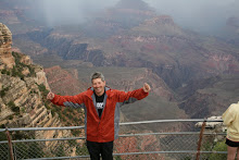
 I felt a little out of it at the top. I walked around the summit in a daze and took some pictures. I spoke to a few other riders (all of them on smaller bikes). They assured me the ride down was easier. Despite the assurances of the other riders, I was genuinely worried I would dump the bike on the way down, but I was beginning not to care. Everything was kind of fluffy and funny. There’s another word for a Rocky Mountain High, it’s called Hypoxia. I knew I was in trouble when I went to leave and I could not remember which side of the road I should be on – I’m serious.
 It turns out the other riders were right. The ride down was easier. I kept the bike in the lower two gears, and kept my hands off the front brake. The front brake on a bike at low speed is good for one thing – falling. It’s like the gravity engage switch. You pull it at slow speeds and the bike falls over.
I had selected the right clothes for the trip. I had dressed in layers and though it was cold, I was not uncomfortable during my ascent. I was cold at the summit. I was actually shaking, but that could have been fear. This is good because the high country around the southern rim of the Grand Canyon is notoriously cold. I shed some of the layers as I descended.
 I stopped often on the way down. I had less fear about getting the bike going the right direction going down. That would happen with or without me. I took about 150 pictures. I went on a small hike. I could not believe how hard a relatively simple hike was at those altitudes. I finally made it down and back to Idaho Springs by 1:00pm.
In case you're wondering about the white stuff in the photo. It's snow. There was lots of it, but all on the side of the road (it's August).

When I reached the B&B, I found a note on the door. It said I was the only guest and the owner would be gone all night. I had the place to myself. There were instructions on how to lock the door at night and a promise of breakfast in the morning. So much for human contact….
4 comments:
Sounds like you're having a nice trip so far. I figured I'd post to provide some "human contact", html encoded as it is. It's great you made it to the top. I can't imagine the air being so thin to affect you so much. I look forward to your continued posts.
I too am glad you made it. I will tell mom as I head upstairs to bed. Bummer on the lack of human contact at the B&B, but if that is the worst thing that goes wrong, I will be eternally grateful. Beats a mad dog introducing himself. The ride up the mountain sounds awesome. Terrifying, but awesome. I can't imagine adding chemicals to the hypoxia would do anything except cause a Rocky Mountain Crash (figuratively and literally). Glad you are safely under 7,000 feet.
I'm really enjoying your blog, especially as you travel on bike to places I've been by car. When Cathy and I drove from Baltimore to Colorado (back in Bicentennial times), we, too were impressed with the flatness of Kansas. We didn't see a tornado, but we did see a line of fire perpendicular to the highway - the fuel-conserving-carbon-emitting method of clearing wheat stubble. Wonder if they still do that?
The cute little prairie dog relatives are called marmots. We saw them all over Pike's Peak, where they also have plenty of snow in the summer.
Nice work on the pictures, too. Can't wait to see the rest.
You know me and heights, I was neverous just reading... the pictures are amazing, I can't wait to see the rest. Thank you for allowing us to follow you on your adventure. Its so great to "see" you!
Post a Comment